In search of a strategic and central route through the Apennines.

In the Historical Cartography of the Tuscany Region (CASTORE, 1840 Cadastre), the complete map of the territory where the village of Pariana is located can be found. From Borgo a Mozzano, after crossing the Ponte alla Maddalena — popularly known as the “Devil’s Bridge” — two roads can be seen starting to climb from the village of Maddalena on the left bank of the Serchio River, marked as the Via di Malpasso and the Via dei Cavalli.

(two very significant place names). The two roads — mule tracks paved with cobblestones — merge before reaching Corsagna, and from that point onward, the single road is indicated as the “Road from Ponte alla Maddalena leading to Corsagna and Pizzorna.” The road passes by a locality called “Fontichi,” which can reasonably be interpreted as “Fondachi,” meaning warehouses for goods located along the routes, where merchandise, mules, horses, and the men accompanying them (known as carters) could be sheltered overnight.
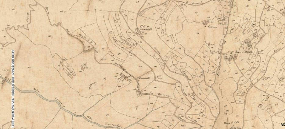


After passing the locality of Pizzorna, the route meets another road coming from the right, known as the “Sezionale Road called Garfagnina,” which, descending from the mountains in the Brancoleria and Capannori/Porcari areas, led to the Ponte alla Maddalena and from there into Garfagnana, continuing beyond into Lunigiana and the Po Valley. It connected through the many Garfagnana passes (notably the Ospitale di Tea, San Pellegrino in Alpe, and Pradarena), towards Modena, Parma, Reggio Emilia, Bologna, Pontremoli, and Mantua. As shown on the map, the Pizzorna Road, however, continues its course eastward.

The Pizzorna Road continues onward and, at a certain point, branches off toward Boveglio and Colognora, but its main route, still called the Pizzorna Road, continues directly toward Pariana (with the place name “Al Colle di Pariana” appearing further up).


The matter, therefore, is extremely interesting. The map, although dating from the late 19th century, documents the road — always referred to as such, using a term (“Strada”) that highlights its importance as a paved “Via Strata” — which, from the Ponte alla Maddalena at Borgo a Mozzano, led, passing through the Pizzorne and Pariana, to Pescia, Pistoia, and from there, through the Valdinievole, to Florence. It was a major commercial route of absolute and primary importance. A road that lay entirely within the territory of Lucca, underscoring the attention that Lucca paid to it.
On the other hand, as mentioned, the urban structure of Pariana was that of a caravanserai (a “new land”), a closed settlement providing shelter for goods, mules, and carters — one of the many lodging and hospitality structures spread along commercial roads. The Casa Passeri itself — a family central to Pariana in the 16th century, which produced Francesco Passeri, a fairly well-known painter also involved in violent events — stands along this road, and the Passeri were certainly a wealthy family of artisans or merchants.
The “power” of the Porta Pizzorna, through which one enters Pariana, highlights the importance of the commercial village.

Gruppo Donatori di Sangue Fratres di Pariana
Via Regina Margherita 13, Pariana, Villa Basilica (LU), 55019
CF: 9200234046
Follow us on